|
|
A long and strenuous walk, and one
of the best that we know.
For this walk, you need OS Landranger 200, Newquay &
Bodmin.
Severity
of walk
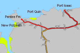
Port Isaac is a lovely fishing village
and a good place to start this walk. A few years ago, a chough
was found at Pine Haven just along the coast; unfortunately,
several had been bred in captivity and had been released without
a licence, but it was nice to see it anyway. The views from Kellan
Head are superb: Westward, The Rumps can be seen, while northwards
you can see the radar station at Morwenstow beyond Tintagel Island;
on a clear day you may see Lundy. Port Quin lies at the end of
a long inlet of the sea, and is now just a few National Trust
cottages; but a pretty place to walk through.
Park the first car at Pentire Farm at the old leadmine
(NT), grid reference SW 942 800
What 3 Words: pillows.polka.nozzles
N 50°34'59.85" W 4°54'35.33"
Follow the B3314 from Wadebridge on signposted to Port Isaac,
and turn off on a minor road when you see a golf-club sign: This
road goes straight ahead while the main road has a sharp right-hand
bend. Turn left at the junction, then follow the signs to New
Polzeath until you see a small crossroads with a caravan site
indicated on the left. Turn right, and follow the narrow lane
along, then down past farm buildings, then sweeping up and left
through a gate and cattle grid onto open ground. Follow and look
for the National Trust "Leadmines" car park. If you've
not been here before, take time to walk over the back and follow
the short path that leads to the coastpath. When you arrive here
later, you'll know where to turn off for the car park.
Park the second car in the car park at Port Isaac, grid reference
SW 999 810
What 3 Words: kipper.ditched.songbirds
N 50°35'40.02" W 4°49'41.27"
Retrace your path, this time keeping straight ahead after
the Bee Centre, rejoining the B3314. Continue, turning left onto
the B3267 to Port Isaac. Follow the car park signs to the right,
towards Port Gaverne and turn into the car park on the left.
|
|