PENCARROW
HEAD TO POLKERRIS
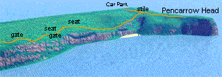
From the car park, walk up to the main road, straight
across and through the gate opposite. Follow the path and turn
left at the gate. When you get to the next gate, you'll see a
stile on the right; over this, and you're now on the coastpath
bound for Polkerris.
It's a steep path down, but beautiful scenery ahead; it's
only a short distance before the path rises again - at the top
is a seat, turn round and admire the view of Pencarrow Head;
it's terrific!
|
 My impression of
the start of the walk..no use, but pretty!
My impression of
the start of the walk..no use, but pretty! |
After Blackbottle rock it's a nice downward path which stretches
out in front of you; then up a short steep bit, over a stile
and the path goes down in a narrow cutting - there's a brook
here, and this area can be a bit wet! The path then goes across
an open area before rising upwards (past a sheltered seat where
we had lunch) to a gate leading to the tarmac of Polruan. Turn
left and keep to the left; past the school and the Coastguard
station. Keep to the left-hand side of the car park and follow
the path; it's a tortuous route, but well-defined - take a look
at the 15th Century Blockhouses if you wish, otherwise go right.
Eventually you end up at the jetty where you have to wait for
the ferry to Fowey.
|
If it's low tide you'll probably be taken to the quay in
Fowey: If this is the case, turn left and past the aquarium,
follow the road round then turn left:- I had more explicit instructions
recorded on my dictaphone (an old voice recorder)...but it didn't
record; so I've got to rely on memory yet again! Anyway, follow
this road; it later becomes Esplanade Rd (I think!); further
along is the quay that you will walk from if it's high tide;
and you will eventually drop down into the quaintly-named Readymoney
Cove (I'm told, named after the Redmond family-not a shipwreck!).
Walk through, don't take the left-hand path, but walk up the
right-hand path (part of the "Saints Way") away from
the sea; further up is a path to the left - take this, which
becomes quite steep towards the end. Ignore the right fork, though
they later join again, because just around the corner is St Catherine's
Castle which enjoys commanding views of the River. Carry on and
upwards to a gate which leads to an open space which was donated
to the people of Fowey by a local landowner whose name wasn't
recorded on the non-recording dictaphone!
|
|
Keeping to the left, follow this path, it's fairly level
here, then you come to Coombe haven (or Hawne). The path rises
steeply out of here then levels before rising for a long way
until you come to a small sheltered dip: After this the ground
levels before a long vista opens up in front. The path is sloping
downhill for a long way, and in front of you can be seen Gribbin
Head: A lot nearer than before, and you can now see the steep
hill leading to the marker at the top.
At the bottom of the hill you have to turn right and upwards;
after a short stretch, over a stile and follow the path down
to Polridmouth - a lovely beach and lake, with a very nice house
as well. Out of here, and once again you're walking upwards,
then downhill slightly, and then you see the problem:- It's steep!
Just take your time, the steepest part is at the beginnng; after
that it becomes less acute, but it's quite a hard climb (look
to your right and you might see Menabilly: Daphne du Maurier
lived here). Once at the top, recover your breath, have a drink
and continue: Walk towards the gate on the left NOT the wood
over to the right; follow downhill for a short way before climbing
once again (but it's beside a wood and quite pretty, so not too
bad!) before dropping slightly as you approach Little Gribbin
as the path turns into St Austell Bay with extensive views of
Par, St Austell and the beginning of The Roseland Peninsula.
|
|
After this the path stays fairly level with small ups and
downs for most of the way to Polkerris. The surroundings change
from open areas to sheltered paths followed by open fields. Finally
comes the last steep section to bring you overlooking Polkerris
through the trees: After a stile you will see trees on your left
with an almost sunken path in front - there are gaps in the hedge,
so hop over and follow the path downwards to bring yourself to
the outskirts of the village. Turn to the right and simply follow
the road out of the village, up the hill and back to the car
park.
Finally say "Thank you Colin, that was a hard walk!"
|
|
|